CGM Viewer User Guide
Community Geodetic Model (CGM) Viewer Overview
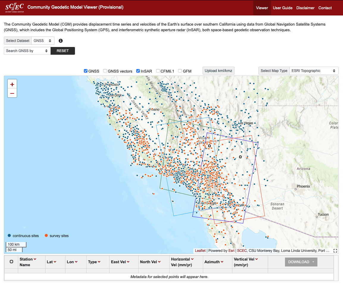
The CGM viewer provides interactive map-based views of the CGM version 2.0 contributed products. The viewer allows users to select GNSS or InSAR products of interest, using drop down menus at the top-left of the interface, and view the results. Users can view overlays of GNSS station locations and velocities (relative to North America), InSAR track footprints, Community Fault Model fault traces and Geologic Framework Model regions. Users can also download selected product data without having to download the entire CGM product archive. The pages on this site include the CGM viewer page, this user guide, a disclaimer, and a contact information page.
The interactive map on the right displays the geographic extent of the CGM products, using the selected metric for the selected data type. In the top-right corner of the interactive map, there is a pull-down menu that allows the base map to be changed. By default, the map shown is ESRI Topographic. The other map types are: ESRI Imagery, Jawg Light, Jawg Dark, OSM Streets Relief, OTM Topographic, OSM Street, and ESRI Terrain.
The map interface has a small default size, but the map interface can be resized by clicking on the black dashed square icon located in the bottom right corner of the interface. Two size options are available, default, and full-screen. The full-screen size hide some of the tools, so this option is provided for visualization and data comparison purposes and is not intended to be used when querying the product for download.
To report any bugs or issues, please see the contact page.
Display Layers
Along the top of the map, there are checkboxes that turn on or off additional display layers, which the user may find helpful. “GNSS” adds GNSS station locations. “GNSS vectors” adds GNSS station velocities, relative to North America. These location and velocity values populate the table underneath the interactive map after selecting stations (described below). “InSAR” adds the outlines of the InSAR track footprints. “CFM6.1” adds the surface traces of version 6.1 of the Community Fault Model faults, with blind faults indicated by a dashed line. Click on each individual fault to see a popup of its name. "GFM" adds the Geologic Framework Model regions defined as a component of the Community Rheology Model. Click on each individual polygon to see a popup of the region name. "KML/KMZ Uploader" allows users to upload their own Google Earth kml/kmz files for display on the map interface. The kml/kmz uploader currently supports point/line data (kml/kmz) and image overlays (kmz only). kml/kmz files with remote links are currently not supported.
Explore CGM products
The CGM viewer has two available sets of geodetic products (GNSS and InSAR) and a few modes by which to select them. The "Select Dataset" dropdown menu, in the top-left corner, is GNSS by default. If "InSAR" is selected, a "Select TracK" dropdown menu appears adjacent, which displays nothing ("NONE") by default. Select a track from this second dropdown menu and the coverage of the chosen InSAR product is displayed (this may take up to one minute to load) with a corresponding color scale of line-of-sight velocity in the bottom-left of the map. Line-of-sight velocity is referenced to the GNSS station location marked by the white square corresponding to the track.
-
To select the GNSS products
- Hover over a station icon to see a pop-up showing the station ID and nominal velocity relative to North America.
- Select a specific station directly
by clicking on its icon, or choose a selection method using the
"Search GNSS by" dropdown menu below "Select Dataset" in the
top-left corner.
Options are:- Station Name, enter the station name and press return.
- Latitude & Longitude Box, either enter the latitude and longitude of the lower-left and top-right points or auto-populate the fields by clicking-and-dragging to draw a box within the interactive map.
- Vector, which automatically displays the GNSS vectors (see "Display Layers"), then select a range of velocities with the slider.
-
To select the InSAR products
- After track selection, as described
above, use the "Search InSAR by" dropdown menu to select a point or
mark a region.
Options are:- Point Location, clicking on the interactive map to choose a point.
- Latitude & Longitude Box, either enter the latitude and longitude of the lower-left and top-right points or auto-populate the fields by clicking-and-dragging to draw a box within the interactive map.
- After track selection, as described
above, use the "Search InSAR by" dropdown menu to select a point or
mark a region.
-
To visualize the selected products
In the case where GNSS stations are selected individually or by a selection criterion, or where InSAR is selected by points, the time series associated with those locations is available to view by selecting the “plotTS” button in the table populated with selected points below the interactive map. In the case of GNSS, the reference frame may be changed by select one among the GNSS frame type buttons in the top-left and other buttons along the bottom can close, reset or save the time series; select “Help” for details.
Select Points or Region to Download Data Subset
Once a product and specific points or regions have been selected, as described above, users can download the subset of data by checking the box(es) in the left column of the table below the interactive map and selecting “Download” in the top line of the right column the the table. For GNSS, this will prompt the user to choose a reference frame or download all: igb14 is the International GNSS Service’s (IGS’s) second version of the International Terrestrial Reference Frame (ITRF) 2014 (Altamimi et al., 2016); nam14 is relative to North America, defined for ITRF2014 (Altamimi et al., 2017); nam17 is relative to North America, defined by Kreemer et al. (2018); and pcf14 is relative to the Pacific, defined for ITRF2014 (Altamimi et al., 2017). The format is GAGE’s “pos” format. For InSAR, this will download LOS time series data files in "csv" format for selected points and composite velocity files in "csv' format for selected regions. Click the downward arrow within a circle by "Select Track" dropdown menu to download the full HDF5 file for the selected track at any time.
References
Altamimi, Z., Métivier, L., Rebischung,P., and Rouby, H. (2017). ITRF2014 plate motion model. Geophysical Journal International, 209, 1906–1912. https://doi.org/10.1093/gji/ggx136
Browser Requirements
This site supports the latest versions of Chrome, Microsoft Edge, Firefox, and Safari.
More information, including a complete model archive, can be found at: https://www.scec.org/research/cgm.